Development   of   Amsterdam
 
Nederlandse versie updated  21-09-2010
Keitje's Home
Netherlands
Amsterdam
 » development
    city palace
    architecture
    city furniture
    public space
    dogshit
    go around
    tourism
    voice
Jordaan
Fotoserie
Archief
hondenpoep
the complainer
 
beginning     growth     trade     war     heritage     now


beginning

About one thousand years ago large areas from and around the present Amsterdam were just swamp and peat and stood largely under water, making it that from the beginning on transportation was done by boat. The oldest and at that time not unimportant settlement (stelle in the Frankische language) with a church and market in the region of present Amsterdam is the more southern situated Aemstelle: nowadays known as the town Ouderkerk aan de Amstel.

The family Heren van Aemstel (Lords of Amstel) played from the 11th until the end of the13th century a leading role in the development of the Amstelland (a territory owned by the Roman Catholic diocese Sticht Utrecht). The last one of them, Jan van Amstel, has been poetized by Joost van den Vondel in his famous play Gijsbreght van Aemstel.

On the small delta, formed by the river Amstel (then called Ammerak, whereby aem and rak mean in the old-Fries language respectively (river)mouth and the big water) which flows here into Het IJ, and by the river Boerenwetering (now the Nieuwezijds Voorburgwal) which runs in the Amstel at the present Nieuwezijds Kolk, arise in the 11th century a couple of small hamlets. With Het IJ so close to the (in the northeast laying) turbulent Zuiderzee means each time fighting against the storm tides threatening the first hamlets. 
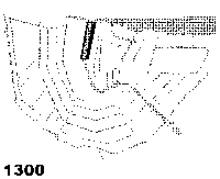
Around the turn of the 12th to the 3th century a sort of dam is constructed where both rivers flow in Het IJ. Halfway the 13th century a real dam is built in the mouth of Het IJ as a means to fight against the wild water, resulting in a good loading and unloading harbour. With this so created Plaetse also called d'Ammerak is at the same time the Heart of Amsterdam born, now known as Damplein (Damsquare). A hamlet is developing on the spot of the present Wallen and dikes are built along the river Amstel.

In the middle of the 14th century these couple of hamlets together form the base for the first settlement of Amsterdam and is for the first time mentioned in a writing dated 1275: in that year count Floris V of Holland grants a toll privilege (tax-exemption) to the 'lieden wonende te Aemstelledam'.
Notice, the word Aemstelledam does not necessary mean it has anything to do with the river Amstel, it may also be a combination of the previous mentioned words aem, stelle and dam.

Amsterdam obtaines in 1300 of 1301 her city rights but a few years later she must give them back, possibly due to the city's couple of weeks of lodging in 1304 of the last Lord Jan van Amstel, just before his definitive defeat. In 1306 Amsterdam gets her city rights once and for all: she is allowed to run itself, independent of Bishop, Count and Lord.
For centuries the (every time chosen for one year) council exists of four mayors and the vroedschap (town fathers) , being an elitist group of 36 merchants. They carry out all the city tasks except the rechtspraak (law and justice). This is done by one schout and 7 to 9 schepenen.

The city is quite young and small in comparison to other, much larger cities at that time like Haarlem, Leiden, Nijmegen, Utrecht and Dordrecht. However, in the middle of the 15th century Amsterdam is strongly coming up, not in the last place for its popularity among the pilgrims.

The language spoken in Amsterdam is from origine Frisian, but through trading and seagoing the Low German language largely takes over. It is the immigration of all kind of cultures in the 17th century that provides the different neighbourhood bounded accents. Two centuries later only half of the Amsterdammers speak with Amsterdam accents.

Because of the attraction of the city her boundaries must repeatedly be enlarged, which means in the beginning the digging of canals and erecting of city walls for military protection. The terms Oudezijde and Nieuwezijde in streetnames are no time indicators, but refer to the parish deviding of the Old and New Church. The city enlargement starting in 1612 is at that time the largest in the world (the city is getting one and a half times bigger) and, inspired by the Renaissance, an ideal city will be built: one is a chic residential area, laid out in a half circle, now known as the Grachtengordel (canal girdle), being everything inside Herengracht and Prinsengracht, the other is the Jordaan, meant for the small and large industries (like the 'lijnbanen', roperies). The first canals are dug out for defence reasons, but they got soon more important for freight reasons. The three canals (Heren-, Keizers- en Prinsengracht) are laid out as waterways for their new inhabitants: merchants who became rich by oversees tradings.

For some centuries no expansions are done. For a long time the city is in huge economical problems. Even people are moving out to other cities in Germany and Belgium. There is a lot of poverty and slums are formed.

At the end of the 19th century the city council decides to fill up several canals to fulfill the wishes of the merchants with their booming horse-and-wagon traffic. Many canals are being filled up. But when in 1901 the Reguliersgracht threatens to be filled, the protest of the Amsterdam citizens is so intense that the city stops with further destroying its canals.

In the 20th century there is again a population growth and, with the demand for larger living space per person, large scaled uniform districts are being built and after that new and independent socalled tuinsteden (garden cities) arise around Amsterdam.

With the installing of the storm flood barriers (large lock gates, which in emergency can seal off the mouths of the Amsterdam canals and rivers from Het IJ) and the finishing in 1932 of the afsluitdijk (the IJsselmeer Barrier Dam) which devides the IJsselmeer from the Wadden Sea, the waterproblem is possibly solved for a very long time.


growth  of the old center

Amsterdam starts to spread out and after the 17th century it does that by digging canals in the shape of half concentric circles around the 13th century root. Tzaar Peter the Great is so impressed by the canals and bridges after a visit to the city in1697 that he uses this poldermodel as a base for the new city he wants to build on peat ground  Sint Petersburg.


  • 11th century: a few settlements
  • 1300: from Het IJ until the Munt and within the Nieuwezijds and Oudezijds Voorburgwallen
  • 1380: east: Oudezijds Achterburgwal
        west: Nieuwezijds Achterburgwal (now Spui)
  • 1425: east: now Geldersekade and Kloveniersburgwal
  • 1450: west: Het Singel
  • 1585-1593: west, south: Herengracht
        east: islands Uilen-, Valken- and Rapenburg
  • 1613: westelijke grachtengordel (western canal girdle)
  • 1614-1640: Jordaan
  • 1663: oostelijke grachtengordel (eastern canal girdle)
Innercity of Amsterdam
zie Amsterdam groeien
growing of the old city
This whole area lays in between the Singelgracht and is now called Binnenstad (Inner city) of Amsterdam. Every expansion also means building a new expensive fortress wall.
Notice that on most maps the north of
Amsterdam is pointed downwards


trade

Trading is always been the main source of income for Amsterdam. First exporting fish and beer and importing salt for preserving ("pekelen") the fish. Later also exporting butter and cheese and importing spices and coffee by the Dutch shipping company VOC (United Eastindisch Company). The storage of the products results in building the large monumental warehouses ("pakhuizen"). Most of them have recently been turned into expensive appartments. With the discovery of America the Dutch shipping company WIC (West Indisch Company) starts in 1626 the slavetrade from West Africa to Surinam in South America and to North America, to work on the plantations, mostly owned by Dutch immigrants. In 25 years time more than 14,000 slaves don't survive the passage. It is a misconception to think that the slave trade is a profitable business.

This 17th century is for Holland and especially Amsterdam a Golden Age and is called that too.


Amsterdam and World War II

Being Dutch we are used to always obey our governments, in spite of our grouching. We much rather offer resistance by means of writing and protest actions, than with practice-based doings. (read Han van der Horst The low sky, pag 155+). When during 1940 and 1945 the Jews and communists are thrown out of the Amsterdam Civil Service office, there are no protests coming from the City Council. The Amsterdam police is eager to help the Germans, while the Civil servants are very docile. Also the NS (Nederlandse Spoorwegen = National Dutch Railways) doesn't mind to cooperate with the Nazis. Some of the Amsterdam citizens themselves disgracefully betray and plunder their fellow citizens and neighbors.
Read Han van der Horst: The Low Sky, pag 155+.

But the large part of the non-Jewish society of Amsterdam stands up for them. For this last behaviour our Queen Wilhelmina (who plays a controversial role during WWII, which is always a very delicate subject) gives on 29 march 1947 to the brave Citizens of Amsterdam (not to the City Council!) the Right to add to the city-arms of Amsterdam the text (Heroic, Firm, Charitable):

    Heldhaftig, Vastberaden, Barmhartig


old foundations


kasteelmuur N.Z. Kolk
western wall NZ Kolk


zuidwestburchtmuur N.Z. Kolk
southwestern wall NZ Kolk


voczeemagazijn Oostenburg
VOC sea depot
Oostenburg


not restored
gevelstenen
restored
heritage

In March 1994, while digging necessary for constructing a large building project at the Nieuwezijds Kolk, an old wall appeared. It turned out to be a fortress wall from the 13th century. It is unlikely to be the fortress of the Heren van Aemstel. The Amsterdam Tourist Board is in favor of exploiting this piece of heritage commercially with a multi-mediashow. The archaeological department as well as alderman Ruud Grondel want to build an archaeological museum above the wall which is part of the oldest stone building of Amsterdam. The real estate developer want to start as soon an possible with its complex of houses, shops, offices, a parking garage and a hotel. Because of the usual lack of funding the plot is filled with sand and the building of the new complex on top of this piece of inheritance is a fact. As a type of conservation for future generations.
In 1996 the Amsterdam archaeologists did some ground testing with radar in that area. With the cooperation of the builders a tunnel is scooped out in October 2002 and more old walls have been found, this time on the southside of the area. Further investigation in February 2006 made it possible to reconstruct the archaeological site; it appears to be a square brick-walled fortress.
See Nieuwezijds Kolk and nieuw deel.

On the harbour island of Oosterburg, which is build up in 1660, a slipway of the VOC has been found in 2000. Halfway 2001 the remains of the shipyards appeared where the VOC built between 1660 and 1800 more than five hondred large wooden ships. One year later in the same area a small part of the foundations of the VOC sea depot became exposed, at the time the largest building in Europa: the distrubution center for the merchandise of the VOC. All these excavations are (the latter will be) filled with sand and built over.

The introduction of the gable stone (gevelsteen) which is placed just above the door or (later on) high up in the middle of the façade, dates as far back as 1486. They were used as a house sign by businesses and people with specific professions and are not typical for Amsterdam, but occure in other places like Maastricht. Many of them are restored in the last decennia and put back in the façades, mostly on historical wrong places. Some are simple, some intricate and colorfull. There is also an association, called VVAG (Foundation for the Friends of the Amsterdam Gable stones).
The introduction of house numbers as we know them now is not before Napoleon-II. In between that period the city of Amsterdam uses all different type of lot-numberings, all based on a clerck type of way and virtually not usuable for daily citylife.

During the second part of the 20th century many of the historical architecture is disappeared thanks to rigorous urban renewals. However, there are still many typical old Amsterdams façades (gevel) left in the old center, in the canal girdle (grachtengordel) with her manorhouses, and in the small streets of the Jordaan. For conservation and renovation there is the VVAB (Foundation of Friends of the Amsterdam Innercity).


archeology at the
Nieuwezijds Kolk

zuidwestburchtmuur N.Z. Kolk


zuidwestburchtmuur N.Z. Kolk


zuidwestburchtmuur N.Z. Kolk


zuidwestburchtmuur N.Z. Kolk


renovatie


and now

A large collection of all kind of big and small projects are taken place in Amsterdam at the moment. All of them are taken much longer and with more much expences than planned.


to the top to the next page
©keitje I'm not complaining , just explaining